
Rediscovering the Past
|
Mapmaking
Mapping the past
       
Maps connected the world and enabled modern states to function effectively.
In the 19th century, the European drive to document both the natural and material worlds extended to the ancient world. The sites of ancient cities were located, surveyed and mapped in increasing detail. Many such maps were made by well-educated military personnel with the best surveying skills and use of the latest technology. After World War I, aeroplanes were put to use in a new type of archaeological survey. The Palestine Exploration Fund’s pioneering Survey of Western Palestine was a monumental effort, encompassing all aspects of the territory. The focus was on the archaeology of the Holy Land, but it also helped with the administration and development of the region. Maps became so central to archaeology that the Ottoman Antiquities Law of 1884 demanded proper maps as a prerequisite for excavations. This prevented casual, amateur exploration and ensured scientific standards.
|
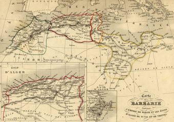

Map (la Barbarie)
1843 National Library of the Kingdom of Morocco, Rabat, Morocco Alexandre Vuillemin This mid-19th-century map shows Morocco and the states of Algiers, Tunis and Tripoli. The place names are given in French. Originally in monochrome, the owner added colour to emphasise boundaries. Related 
|
||
|
|
 / Download