Collections | Economy and Trade | Trading routes [45 Objects, 4 Monuments]
19th century
National Library of France
Paris, France
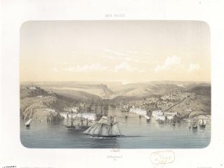
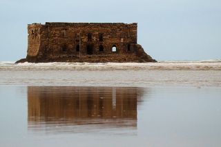
The Black Sea, whose western shore connected the Ottoman Empire with its European possessions, was for centuries under the control of the Ottomans and no foreign vessels were allowed to sail or trade on it. This monopoly was lost in the late 18th century when Russia was granted navigational rights after the Russian-Ottoman war of 1768–74. Later, the Treaty of Edirne (1829) gave the same rights to all European countries at peace with the Empire.

First half of the 19th century
National Museum of Romanian History
Bucharest, Romania

1820
National Library of France
Paris, France
Alexandria, 19 April 1838
State Archives of Livorno
Livorno, Italy

Constantinople, 7 June 1841
State Archives of Florence
Florence, Italy

Map of Algeria's commercial routes to the 'Pays des Noirs' [Guinea]
1850
National Library of France
Paris, France
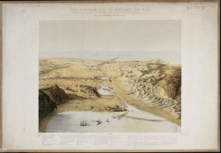
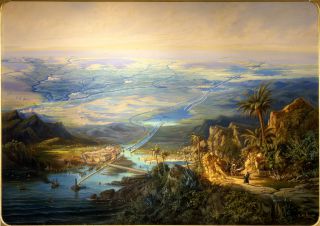
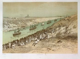
Panoramic view of the Isthmus of the Suez, tracing the canal between the two seas
1855
National Library of France
Paris, France
The construction of the Suez Canal was not a 19th-century idea, but actually represented the re-establishment of an ancient trade route between Europe and Asia. The first canal to connect the Mediterranean and Red seas had been built by Egyptian pharaoh Necoh II in the 7th century BC, but was blocked by the Abbasid caliph Al-Mansur in the late 8th century AD.
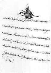
Firman issued by Sultan Abdülmecid for the construction of the Constanţa–Cernavodă railway
1857
Romanian Railways Museum
Bucharest, Romania
Constanţa–Cernavodă, the first railway in the European part of the Ottoman Empire, was built to facilitate the transportation of exportable products, especially cereals, to the Black Sea port of Constanţa, from where they were shipped to Istanbul.
1864
Revoltella Civic Museum
Trieste, Italy
Since the discovery of the trade route to India in the 15th century, Europeans reached the Arabian Peninsula by circumnavigating Africa. This changed in the late 19th century when the Suez Canal made it possible for ships to sail from the Mediterranean directly into the Red Sea.

1865
State Archives of Trieste
Trieste, Italy
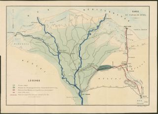
In 1869 the opening of the Suez Canal, which was built to unite the Mediterranean and the Red Seas, marked the inauguration of a shorter trade route between Europe and the Arabian Peninsula.

1869
National Museum of Romanian History
Bucharest, Romania
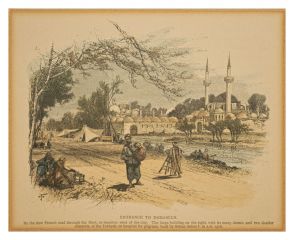
The main caravan routes used in the Balkans for the trade with the Ottoman Empire all led to Istanbul. Two of the most important were ancient roads that had been built by the Romans. One (Via Militaris, 1st century AD) headed to Istanbul by passing through Belgrade, Nish, Sofia, Plovdiv and Edirne. The other (Via Egnatia, 2nd century BC) passed through Dyrrachium, Edessa, Pella, Thessaloniki and Edirne.
September 1876
State Archives of Trieste
Trieste, Italy


1882
The British Library
London, United Kingdom
The Gulf of Aden became in the late 19th century part of the new trade route created between Europe and the Arabian Peninsula through the construction of the Suez Canal. After crossing the canal and accessing the Red Sea from the Mediterranean, ships sailed the Gulf of Aden to enter the Arabian Sea and then the Indian Ocean.
Published 1881–1884
Sharjah Art Museum / Sharjah Museums Authority
Sharjah, United Arab Emirates (Sharjah)
In 1863 a carriage road was built between Damascus and Beirut by a French company under Ottoman jurisdiction (Compagnie Impériale Ottoman de la Route de Beyrouth à Damas). This had a positive influence on silk exports to France. Silk was transported by land to the port of Beirut and then by sea to Marseille.
1880s
National Library of France
Paris, France
The legal status of the Suez Canal was established through the convention of Constantinople (signed on 29 October 1888 by Austro-Hungary, France, Germany, Italy, the Netherlands, Spain, Russia, the Ottoman Empire and the UK), according to which the canal was to be open in times of peace for all commercial vessels.